Camping on public land means there are no bathrooms, no water, no picnic tables, and no trashcans. Bureau of Land Management (BLM) land is camping in its rawest form. I always carry 7+ gallons of water with me, and I have a self-contained commode that I use in the privacy of my own tent. Back east, I carried a shovel with me into the woods, and that sufficed where even the winter trees provide some shelter and seclusion, but in the western desert where there are only scattered, knee-high shrubs, that just won’t do.
BLM land is owned by the federal government and is open and free for camping and recreation. There is very little (read no) BLM land back east, but in the west, there are vast stretches of it.
Between our visits to Guadalupe Mountains and Carlsbad Caverns National Parks, Ella and I setup camp on BLM land in Carlsbad, NM. This particular land was a cleared lot with a dumpster and a rail fence, set aside as a campsite for anyone passing through. There are always a wide variety of campers on BLM campsites, from giant RVs to one-man ground tents and everything in between. Ella and I joined our neighbors, RVers from Washington state, by their campfire after supper and shared stories. Soon, another camper, another solo woman adventurer, joined us. There’s a beautiful camaraderie among campers, especially in BLM sites. We all chatted each other up for several hours under the stars in the cold evening air.
At the National Parks, Ella was not permitted on any trails in the Guadalupe Mountains, nor was she allowed in the cave at Carlsbad Caverns. We did as much sight-seeing as we could in each park, making the most of the scenic drives and public areas.
Guadalupe Mountains NP, TX
Guadalupe Mountains National Park is a hiking park full of wonderful trails, but it is not a driving park, so the few areas we accessed were on the perimeter of the park. The ironic thing is that the mountains driving to the park were extraordinary, more so than in the park. They were tall and jagged, had little vegetation, and were sometimes red, sometimes mottled gray and white, and sometimes dirt brown. The highway cuts revealed a wide variety of rock strata that often looked like misshapen, craggy bricks, haphazardly stacked into some sort of surreal fairytale castle wall. The tallest mountain, El Capitan, is the most prominent, and you see it from many different angles.
In the park, the views are beautiful. The mountains look strong, solid, and powerful. The desert terrain is covered with cactus, yuccas, and shrubs, and the trails are white, dusty sand, lined with quartz and limestone rocks. While I’m confident that the hikes through the mountains are breathtaking, there was not nearly the scenic variety as on the drive in. After visiting all that was available to us, we hit the road.
Carlsbad Caverns NP, NM
The Carlsbad Caverns scenic drive is almost 10 miles of beautiful views of the mountains and valleys in the area. It’s a dirt road, so you can’t drive fast, which suited me just fine since we stop often to get out and walk around. Caves, both low and high, were visible in the faces of the mountains. It was warm in the winter sun, and it was easy to imagine wildlife or native tribes using the craggy overhangs as places of protection, as well as shade from the summer heat.
At the BLM campsite, the couple whose fire we shared had been to the Caverns the day before and said it was exquisite. They spent five hours inside on a self-guided tour, marveling at the formations. Without a doubt this is a park I will return to without Ella. I really want to experience those caverns!
Lincoln National Forest
As we were driving through NM, after seeing mountains that looked similar at three previous National Parks, I was amazed at the variety of this state’s mountainscape. Holy guacamole!
At the beginning of the drive, the range looked like the mountains we left behind – dry, barren, and rocky. As we drove, however, the mountains changed with the elevation. First, they began to be dotted with small, green juniper shrubs. Soon those shrubs were accompanied by cedar trees and pines. Then the mountains were rolling, a steady up-and-down of green hills with a variety of conifers. Sprawling ranches became visible, and grassy valleys were fenced into parcels for cattle and horses. They grew more upscale and sprawling as we continued the drive – one had a small Learjet and dirt runway; one had a flag that proclaimed with unseemly pride, “Democrats are Idiots,” flying next to the American flag.
Before I knew it the mountains were covered with pines, cedars, and other evergreens, and there was a layer of snow on the ground. Birch trees made an appearance. Signs for elk and reindeer crossing emerged. Ski tracks were visible down the ranches’ hillsides. I was now in Lincoln National Forest. I was shocked. I had no idea this repertoire of mountains was in New Mexico’s wheelhouse. There is a full-on ski resort here, called CloudCroft. Who knew? I am still dumbfounded when I think about it!
Snowy mountain at Lincoln National Forest. Photo: Cloudcroft Facebook page
I am sorry I didn’t stop to camp in this lush forest. I was on my way to White Sands and had made reservations at a hotel in Las Cruces for a few days. I desperately needed a shower, to wash clothes, and to catch up on my blog.
Don’t worry, Lincoln National Forest. I’ll be back!
Sometimes GPS doesn’t take you where you want to go, and sometimes you don’t know all the right questions when you ask for directions. Both those were the case when I made my reservations at Big Bend Ranch State Park in TX. There were no reservations left at the National Park, so I planned to stay my first night at a nearby state park before going to Big Bend.
Texas is ginormous and the GPS said it would take six hours to get to the state park from Central Texas. I usually don’t like to travel more than 300 miles in a day because there’s so much to see and because Ella needs to be wild and free, but in Texas you really can’t help it.
Leaving the hill country behind, I clicked Drive and we were on our way. Turns out, the state park is huge – everything’s bigger in TX – and when I arrived, I was at the wrong gate, and it was closed. Getting to the right gate would take another two hours! Ok, forget that; I’ll camp anywhere now. It’s 9:00 pm, and the drive had been way more than 6 hours – more like 8 – and I was exhausted.
I passed an RV park and stopped and asked if they had tent sites. The attendant said sure, and at the same time a young woman walked in asking for a tent site for her and her dog. We parked next to each other, the only car campers in the area, and we spent the whole night talking, sharing stories, and enjoying each other’s company. Her name was Tiara, and she was in her 20’s, had just quit her job, sold everything, and sleeps in her car, traveling the US. She traveled from the opposite direction, so she had just seen CA, AZ, and NM. After her US adventure she’s heading to Europe. She was a kindred spirit and an absolute delight – a breath of fresh air after my dispiriting day.
The following day we went our separate ways, and I went on to Big Bend National Park. What a joy!
Chisos Mountains at Big Bend
The Chisos Mountains are self-contained inside the park, and they are beautiful. The range is huge, which means the park is huge. It took a few hours to drive across it, end to end. Every part of it was gorgeous. I was limited in my hiking options with Ella, but there were plenty of opportunities to see the mountains on paved paths, scenic drives, and from overlooks. Truly breathtaking.
The sand was a light tan, more like dried clay, I assume from eroded sandstone and limestone. The foliage was fairly sparse and suited to this arid climate: yucca, prickly pear, walking sticks, and scrubby shrubs. Most of the mountains were bare or sprinkled with small, green shrubs, but at different elevations the foliage would change. At one point they were covered with small, fluffy, yellow, pom-poms, at another with juniper, cedar, and pines. Some are covered in smooth, slate-gray gravel, some in soft, golden sand, some in bright orange boulders. Bluebonnets were just starting to bloom, and road runners and deer crossed our path.
The views from the overlooks were striking because the mountains stretch seemingly forever. Some views are hazy-blue and jagged, some orangish-brown and flat-topped, some with broad, barren valleys in front of them, and some surrounding small but vibrant river basins. Some are part of a long, continuous series of mountains, and some stand alone like an upside-down funnel. All are awe-inspiring.
There are numerous places to discover beauty, and two of my favorites were the Chisos Basin and the Boquillas Hot Springs. The scenic drive to the Chisos Basin wound upward in the midst of the mountains on switchbacks and hairpins, and the views were magnificent. The road was lined with conifers, maybe the most green there is in one place at the park. The mountains were strikingly jagged and huge, rising into the blue sky, silhouetted against the sun-lit, white, fluffy clouds. There seemed to be no end to the variety of shapes or textures. It was a spectacular drive.
The Hot Springs drive was a one-lane, very winding, white, dirt road that hugged steeply angled cliff faces. The mountains were mostly bald and striated, like no others in the park. This area was not open to RVs or trailers, so once again I was super happy I was in my Subaru. When we got to the destination, Ella was not allowed on the hot springs trail, so I talked to a few volunteers at the trailhead. They said next week would be spring break, and the natural bath would be filled with students. The water is around 105 degrees and feeds the Rio Grande, so bathers would jump from the bath to the river and back again. Ella and I explored the ruins from the original settlers who had built the bathhouse – pretty dang cool.
Boquillas Hot Springs Drive
I’m going to digress here and talk about Texans and how they pronounce Spanish words. Rio Grande is pronounced Rio Grand, coyote is coyot (long o), Guadalupe is Guadalup (long u), San Antonio is San Anton (long o). All the Spanish names are kept, but the pronunciations are Anglicized, or should I say Americanized. The strangest one is Pedernales River, which is pronounced Perdinalis. Texans are adorable. I think it goes back to Texas being a republic and the Mexican Wars, I’m not sure, but you absolutely stand out as a furiner when you pronounce all the syllables in a word!
Camping at Big Bend was a mixed bag. I was at the Rio Grande campground, and it was very crowded. Even the backcountry sites looked full. As I was driving to my reserved site, there was a wild boar foraging in the campground a few sites away. Bears, coyotes, and other critters are expected visitors, but I really wasn’t expecting a boar. I’m so glad Ella missed it because she would have been in full predator mode! After setting up camp and a quick supper, I pulled out my Stargazer chair and relaxed in the dark, staring at the starlit sky.
Big Bend is designated a Dark Sky destination for its remoteness and lack of light pollution, so I was really looking forward to the night sky views. The Milky Way is prominent during summer but not so much in winter, so I knew I wouldn’t get that spectacular view, and to be sure, I saw way more stars than I ever did at home, but because of all the people, the accompanying lights meant I didn’t get the views of the stars I was hoping for.
These campers were off-the-chain social and obviously didn’t know about quiet hours. I usually say the RVers make the most noise in a campsite because they bring children and generators. In this case, it was the tent campers who kept me awake, telling stories and laughing well past midnight. I almost got irritated, but I remembered the night before when I stayed up laughing and sharing stories with Tiara late into the night. Everyone deserves to have a good time and to make sweet and solid connections. Also, laughter is good for the soul, even when you’re just listening to it!
Confused because the GPS guided me to a town instead of a National Park, and because I couldn’t find the visitor center even though I drove directly to the address, and because the only Ranger station I could find was closed, I decided to drive straight to the Hot Springs campground. Maybe there I could make sense of my surroundings. Besides, I knew I needed to get there early if I wanted to camp because they didn’t take reservations.
When I got to the campground, it was a sea of RV’s. I don’t normally mind camping among RV’s, even though they usually have generators that wipe out any feeling of being in the wilderness, but this campground was laid out just like a parking lot. And it was very crowded. I found a Ranger and asked him where the visitor center for the park was. He gave me the address – the same one I had been to – and said it was one of the bathhouses on Bathhouse Row. LOL.
Hot Springs National Park is not like any other. It is, in fact, a town, known for its hot springs of course, but more widely known for the bathhouses that were created back in the late 1800s and early 1900s to service the mafia. Ella and I returned to town and went to the visitor center bathhouse to pick up a map of hiking trails. I decided there and then we would find a more primitive place to camp for the night.
I chose nearby Lake Catherine State Park. It was a pretty park and very well-maintained, but I didn’t know it was a power-generating lake. On the far shore, the focal point was a shiny, purring, well-lit power plant. When I didn’t look in that direction, I could pretend I was more or less in nature.
Our campsite was on the edge of the lake, which was very low for a lack of rain. Each site had a dock, but they were all on dry land – it made for interesting exploration. There were crazy-looking, gnarled tree roots sticking up through the sediment and an enormous driftwood root ball that intrigued Ella. The sun was setting, and the moon rose full and bright, reflecting over the water.
In the middle of the lake was a small island loaded with geese that honked enthusiastically and constantly. Flying in and out and lobbying for position with each other, they were a constant source of entertainment for me and Ella. They never stopped honking. In the middle of the night, when one would honk, all of them would honk. It would create a honking frenzy, and they did this every hour or so, all night long. Their zest for honking was comical and amusing, maybe even motivating. Even with the winter chill in the air, the moon shining brightly, and the impromptu goose sing-alongs, I slumbered sweetly.
Now that I had a better handle on what to expect, the following morning we went back to Hot Springs National Park. We started off at the visitor center where I left Ella tied outside in the care of a park volunteer, and I ran in and did a quick self-tour of the bathhouse museum. It was fascinating! There were four different floors for bathing, therapy, and restoration, and a roof garden for socializing. The curated pictures gave a great idea of what it was like back in the day, and it was quite an event, for sure. Each level had a different function. One was more social, one was therapeutic, one was for individual bathing with dressing rooms and a bathtub in each room. These bathhouses were not community pools like the Turkish baths of yore. It was very obviously an upscale, social, yet private activity. Here the rich and famous found healing and conducted business while fraternizing with mobsters. Today, Bathhouse Row has seven or so bathhouses still on display. Some are museums, but the rest are still fully operational.
Along with feeding the bathhouses, the springs bubble up in several steamy fountains around town. A steady flow of people fill jugs and bottles at all times of day and night. The water is 137 degrees, so you can make a cup of tea straight from the spring. I filled up my water jugs and let them cool before drinking.
Hot Springs National Park is pretty cute. Pretty small. Pretty well preserved. But definitely a city. There are several trails that run up the mountain through the park, all within view of the town, hidden poorly by trees. There are a few scenic drives that switch back and forth through the mountain to make the most of the land area. Scenic overlooks of the Ouachita Mountains have distant views of stores, warehouses, and construction sites.
After the scenic drives, Ella and I went on a few hiking trails. To my delight, fog had rolled in and obscured any visible traffic and shrouded the town below from view. Our favorite hike was the Sunset Trail, amazingly thick with moss and lichens that covered large rocks and tall trees. It was an excellent way to end our visit to Hot Springs.
Ozark Mountains, AR
Before heading south, I wanted to visit my son in Kansas, and that would take me on a northern route through Arkansas. Wonderful! I could do some brief exploring in the Ozark Mountains. After reading a few blogs, I chose several waterfalls that I wanted to see and mapped them out using my GPS. It’s around 20 degrees and snow from a recent storm was covering the forest floors and tree branches, but the roads are clear.
Photo: OzarkDrones.com
The drive through the Ozarks was beautiful and there were very few other people on the road. In fact, the only other vehicles I saw were two snowplows. Odd, I thought, since the roads are clear. As I turned off the main road into the National Forest, the paved road turned to dirt. I had about 20 miles to drive to the first waterfall. It would be slow going.
I was feeling pretty adventurous knowing that I had many miles to travel on this forest road, and as is typical, the more interior I went, the worse the road got. Erosion turned the road into a washboard with divets, potholes, and minor washouts in low-lying areas. The road was wet because of the melting snow.
I started to feel a bit of trepidation but exhilaration at the same time. I was super thankful that I had my Subaru and that I had a rooftop tent and not a trailer or an RV for this excursion. I was really excited about the possibility of being in the sho-nuff wilderness. I had sought out an uncultivated landscape the whole time I was in Hot Springs, and now I was getting a major dose of it.
Snow started to show itself on the road now, not just on the sides of the road. I got out to assess the situation and realized that everywhere it looked wet was really a layer of ice. I started to feel just a little concerned – I had been traveling on a layer of ice this whole time. Even more invigorated, I kept going.
I came across downed trees that a Ranger had cut up a day or so before, sawdust still fresh on the road. I could tell the tire tracks on the road were fresh, and even though I was worried about sliding, and I was on a very narrow road that had a steep uphill on one side and a steep downhill on the other, I felt confident that if a Ranger had gone ahead of me, I was also safe.
This is not my photo. My hands were at 10 and 2, and I didn’t have the nerve to take pictures. Photo: StockFreeImages.com
I felt safe until I came upon some large rocks that had freshly fallen onto the road. They were not covered in snow and the tire tracks did not go around them. My GPS had me turn onto another County Road, and it got even rougher. Now the snow was a couple of inches thick on the road, and there were no tire tracks, so I wasn’t completely assured I would be OK. I couldn’t see what was under the snow, so I didn’t know how stable the road was. It was very narrow with a steep fall on one side and the possibility of rockslides on the other.
Branches and small trees had fallen that I had to maneuver around. I was starting to feel more than apprehension now. My hands were sweating, and I had to take deep breaths to keep the oxygen flowing, reminding myself to breathe. I would find my lips pursed and my eyes dry from not blinking. I was holding my breath again. I would take a deep breath and tell myself, “You’ve got this; you’ve come this far; you’ve got all the equipment you need if something bad happens; you can change a tire; you have lots of warm clothes; you have your satellite communication device; you have plenty of food and water; you have enough gas to keep the car running for warmth if needed; and you have trusty Ella.” While I normally love solo adventuring, having another warm body with you does wonders for bravery.
I had to cross a one-lane bridge over a stream, and the view was beautiful. I wanted to get out and take pictures, but I didn’t dare stop. My phone, whose GPS I knew was working on memory, had no cell service, even with my signal booster. Deer ran across the road in front of me. More rocks and branches had fallen onto the roadway, and I either had to go over them or around them. Either choice could be dangerous.
I am inexperienced and out of my league here. I am not an outdoorsperson, nor an overlander, and I have never been on trips with anyone who is. I’m learning on my own. I’m not really sure what my capabilities are or those of my car. At that moment, I was super glad I had chosen the Crosstrek, which is all-wheel drive and has a higher clearance than other comparable cars. More self-talk. More continuing to breathe. More reassuring myself that I can take care of myself if something bad happens.
It was getting colder, and the sun was bright even though it was lowering in the sky, so the snow was continually melting and freezing. A bank of gray stratus clouds was on the horizon. I started wondering if it weren’t supposed to snow again. Weather in the mountains can be tricky and unpredictable.
After two tremulous hours in the forest with no sign of civilization, I pass a farm, and tire tracks reappear in the road. As soon as I see tire tracks, I start to feel more assured, and my confidence floods back. Even though I see no people, only cattle in the fields, I know I will make it without incident. Pretty suddenly, the road turns from snow back into wet dirt.
The funny thing is, I never saw a single waterfall.
All in all, it was an exhilarating yet terrifying trip through the mountains. I’m super glad I did it! I’m super sorry I didn’t get any pictures! Even when I passed the farm and turned onto a paved road, I had no cell service. Fortunately, I have some good maps, and I navigated my way to the Interstate that leads to my son.
After all that – the very narrow roads, the switchbacks, the ups and downs, and the gorgeous, awe-inspiring, and intimidating views of mountains all around me – I decided it was time for a long stretch of dry, flat land. Kansas here I come!
During the winter flooding, when you get to a certain point on the wetland boardwalk, the path dips underwater, and you find yourself with your soles in the swamp, unable to go any further. Standing in the water-covered foot path, you have a first-hand, eye-level view of the swamp, and the plant life and cypress trees are amazing. The boardwalk stretches for a few miles in a loop and is the perfect vantage point to enjoy the wilderness of the Congaree River. In the winter months the river rises and covers much of the National Park.
After a snowy trip in the Smokies, Ella and I hit the road for warmer temperatures, making our way to Congaree National Park in South Carolina. Arriving in mid-January, I learned that it is a floodplain park, and all the trails that lead to the Congaree are flooded – but not to worry! – a self-guided, boardwalk tour will tell us everything we need to learn about the park, its biosphere, and its significance.
Congaree National Park Boardwalk
We began the tour on dry ground, but as we walked, we could see the water level rise. The farther we walked, the higher the water rose, until we felt like we were smack dab in the middle of the swamp. I kept stopping to enjoy the view and take pictures, and Ella just had no patience with all that. She wanted to go! Where the water rose to meet the boardwalk, a thick raft of leaves floated on top and gathered along the edges, looking like land. Ella, in her incessant need to explore off-track, stepped off the boardwalk into the water and fell up to her shoulders. Ol’ Ella, the swamp dog.
Swamps are full of the most interesting colors and textures. The mosses, ferns, lichens, mushrooms, and evidence of microbial decay are in glorious abundance, and here in the National Park they are protected. The standing dead trees, called snags, are important to the ecosystem because they provide homes to all kinds of birds, bugs, algae, bacilli, and fungi. Snags and their cousins – fallen dead trees, often as tall as 100’ – are a profusion in this park, so you can imagine the cornucopia of decomposition: mycelium, algae, sludge, gloop, muck, and mire. It was glorious!
With each elevation change, the wildlife also changed. At the highest point, squirrels were squirreling, and gnats were gnatting; there were oaks and pines, ferns, tall grasses, wintering vines, and holly. As we continued, the plant life changed steadily. Saw palmettos began to make an appearance and then giant cypress trees. Owls hooted loudly, and woodpeckers took advantage of the snags. Clumps of algae, moss, and lichens floated on the surface and gathered around eroded tree stumps.
Being able to go no further, we turned around and retraced our steps to the other end of the boardwalk where it culminated at the Congaree. A thick brush of water hickories, sweet gums, laurel oaks, and loblolly pines lined the river on both sides, and the water ran a murky gray-green. It looked like every Alabama river I ever saw.
There are several trails that wind through the middle of the boardwalk loop that have a great representation of fungus and mycelium. Dusty colors of gray, blue, green, and purple on the ripples and folds of lichen foliage popped out of dry-rotted tree stumps and looked like bouquets of spring flowers. Tiny white mushrooms grew in long leggy clusters like small stands of trees trying to outdo each other for the sunlight. As the rains continue through the winter, these trails will probably be covered with water too.
Because the Congaree campground was flooded, we went to a nearby state park, Poinsett, and stayed for the night. It was chilly, the perfect night for a campfire, and this was the perfect park for one. In many state parks it’s hard to find enough wood to build a fire, and, in fact, wood gathering is prohibited. This park, however, was full of dead, dry branches of all sizes and widths. Fire making was a breeze, and Ella and I stayed toasty as we tried to spy the stars peeking out between the canopy of branches above us.
Campfire at Poinsett State Park
Both Congaree and Poinsett were very akin to the topography and biosphere of home. It felt familiar. Almost too familiar. I was ready to see more of the US and its natural wonders. The next morning, we walked, had breakfast, and broke camp, eager for the next leg of our incredible National Park adventure!
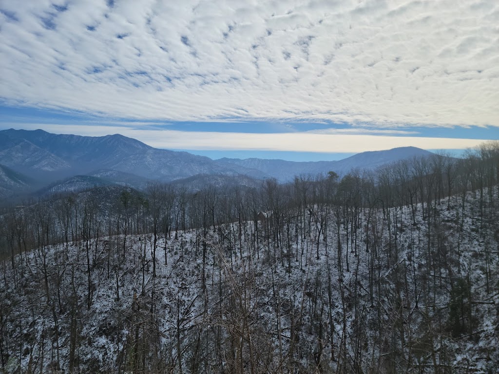
The snow was melting from the trees, dropping in small clumps all around us from the bowed branches, making it look like snow was falling from the clear, blue sky. The ground and bare trees were still flocked with white from the previous day’s snowfall, but the temperatures were slowly rising. I don’t know if Ella had ever seen snow before, but she was delighted. She would march ahead on her leash, imploring me to keep up, sticking her nose into little snowy pockets created by visible tree roots. Trampling under the low hanging branches of shrubs and saplings, Ella produced a mini snowstorm wherever she went, then vigorously shook her cold, wet coat.
Most of the Great Smoky Mountains National Park is not dog-friendly, despite having numerous trails of varying abilities, because of the bears and other predatory wildlife and because of the changes dogs bring to the local ecosystem. This is such a completely reasonable and common-sense rule, I never resent it. There are many other beautiful wilderness areas outside the park we can enjoy exploring if we want to.
This National Park seemingly does not have the marked boundaries of other parks, and there are several visitor centers at different entry points because the park borders Tennessee and North Carolina. Ella was only allowed on two trails inside the park boundary, and they were each at different entry points. Since we were arriving late the previous evening after driving from Mammoth Cave, and because the night temperatures were still well below freezing with snow on the ground, we stayed in a hotel in Pigeon Forge near Gatlinburg. Not only would this afford us some warmth, but it would give me a chance to shower and do laundry. After a good night’s rest and completing our ablutions, we headed out to the Gatlinburg Trail.
We followed the trail along and across the Little Pigeon River, and Ella dragged me down to the water’s edge to dip her toes and nose in and take a drink. At one point, we passed some rapids that were flowing over and around rocks, causing a mist, and we inched our way to the river’s bank. It was getting rather muddy, and we did our fair share of slipping and sliding to get this view. The spray rising into the air hovered over the water like fog. The sound of the whitewater rushing and roiling up through the mist while the snow was falling out of the trees all around us was spectacular. We stood for a spell and took it in.
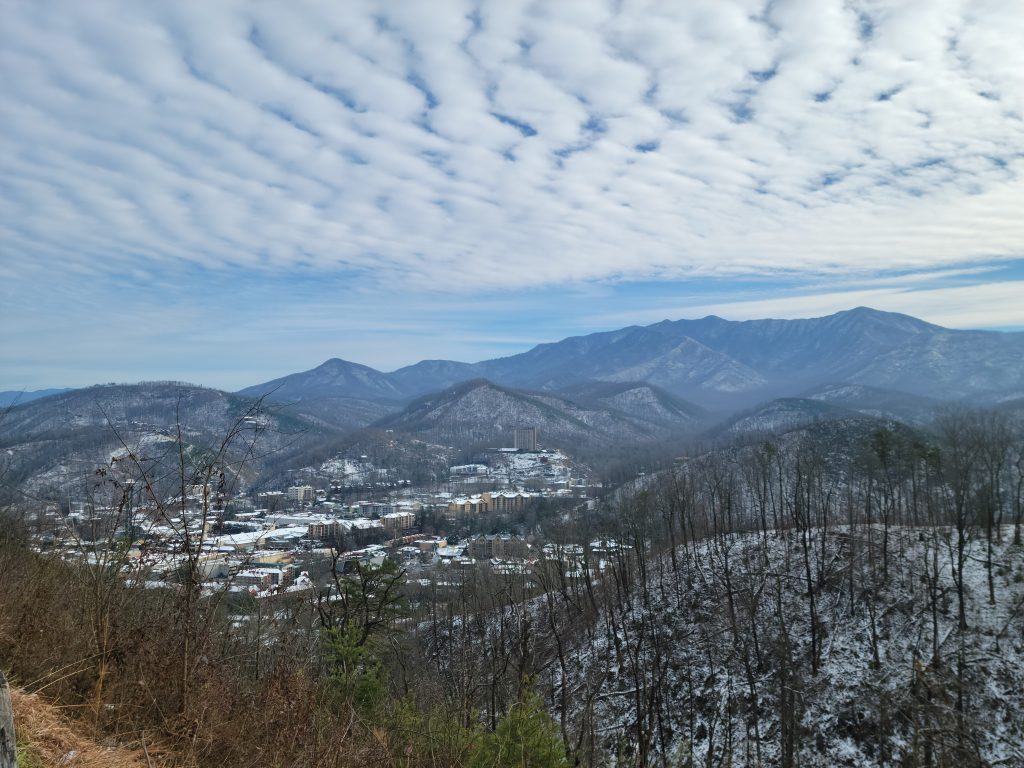
After this satisfying walk, since we couldn’t do much more hiking in the Smokies, I decided to take a scenic drive. Most of the scenic drives were closed, however, because of high water and flooding, but some of the lookouts gave us the classic Smoky Mountain views I was hoping for. Ripples of white clouds were high in the blue sky, and the mountains, covered in evergreens and still spotted with snow, looked gray and purple in the distance, as if they went on forever.
Great Smokies view from Gatlinburg
From there we began our trek south to Congaree to stick with the above freezing temperatures. Driving out of Tennessee was not as picturesque as Kentucky! One of the roads on our route was closed because of flooding, so the GPS redirected us through a small town of old, battered farmhouses and rusted trailers. More and more the town appeared to be filled with old cars – 1970s models with no wheels and missing doors, tractors on cinder blocks, wrecked trucks abandoned in fields. Although it made no sense, at one point I really thought we were in the middle of a junkyard, lost. There were tires and heaps of parts from cars that were half a century old on both sides of the street, and the road was winding in such a way that I couldn’t see ahead. We were the only ones on the road, which was further unsettling. What snapped me into reality was a sign that read, “Slow, school bus ahead.” I felt immediate relief that I was indeed on a road through a normal, small, rural, American town but also dispirited by its dystopian air.
My downheartedness quickly turned to awe as I began the passage through TN into NC, with the Smokies rising up majestically on both sides of us. The road winds through the middle of the range, and the mountains are giant, formidable, and breathtaking. I felt strangely and wonderfully humbled in their midst.